Dor 2009 Preliminary Report
AREA D2: IRON AGE I AND II MONUMENTAL ARCHITECTURE
Figure 3 shows the major Iron Age features in area D2: The curvilinear “Bastion” wall is the earliest construction in the area (built in phase D2/13 – Ir1a, blue in the illustration, or earlier). In phase D2/10 (Ir1b, green) the “Sea Wall” and the “Monumental Building” are abutted to it. “Taphath’s wall” (phase D2/7 – late Ir2a?, pink) is diagonal to the “Bastion” and clearly postdates it – though its relationship to the “Sea Wall” and “Monumental Building” cannot be directly evaluated.
In the area framed by “Taphath’s wall”, the “Bastion”, the “Sea Wall” and the “Monumental Building” the Stern expedition excavated a series of structures (now removed): “Benni’s Building” (Ir1|2 to Ir2a(early) – orange in the attached illustration) is clearly cut by “Taphath’s wall” and was designated D2/8 (with several sub-phases – 8c to 8a). It, in turn, sits on top of a brick structure consisting of several elongated halls, which abutted the ‘Bastion’ and the ‘Sea wall’ and fit – in size and orientation – the ‘Monumental building’ from which it was separated by a narrow alley with a drain running underneath it and through the ‘Sea Wall’ (with which it was integrated). This building was designated phases D2/9 – 10 (Ir1b, green in Figure 3). The lowermost structure (“Nati’s house”, Ir1a, blue) was a stone structure underneath the ‘Brick Building’, which abutted the “Bastion” but was cut by the “Monumental building”. It was designated phases 12 and 13. (Phase D2/11 was an ephemeral set of Ir1b surfaces between the “Brick Structure” and “Nati’s House”.) Phase 13 – the earliest architectural phase in area D2 – ended with some trauma – probably to be equated with the fiery destruction which in evident also in areas B1 (phase B/12), G (phase G/9), and D5 (D5/11).
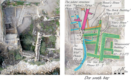
Figure 3 Aerial view of area D2, with major Iron Age remains superimposed on it.
Looking in some more detail at the area excavated in 2009 (Figure 4) we note that the “Bastion” wall, first revealed in this area already at the end of the 2008 season and by now exposed for most of its length – bisects the area into two parts: the inside of the “Bastion” (west of the wall, part of the area we nicknamed "the acropolis")) and a triangular section between the “Bastion” wall and “Taphath’s wall”.
In the latter area, excavation revealed a sequence of two floor surfaces clearly cut by the foundation trench of “Taphat’s wall”. Under these we located an E–W wall which fits – in height and orientation, the walls of “Benni’s House” of Stern’s excavations (W09D2-904). This wall then marks phase D2/8. The surfaces may be what we had called “8a” in old D2 – that had reached the very top of preservation of “Benni’s” walls – or they may be some hitherto un-noted intermediate phase between phase 7 and phase 8. Extensive robbing of the “Bastion Wall” must also have taken place between phase 8 – in which it was used as the back wall of “Benni’s Building” – and the construction of “Taphath’s Wall” in phase 7, during which it was built over. On both the aforementioned surfaces and in the robber trench pottery of Ir2a date was found – including imports of the Cypro-Geometric III period, among which are Black-on-Red fragments, and late manifestations of Phoenician Bichrome (e.g. open bowls decorated in this style, which probably also date to Ir2a, or otherwise, at the earliest, to Ir1|2). Nothing manifestly later than Ir2a was found in any deposit pre-dating “Taphat’s Wall”.
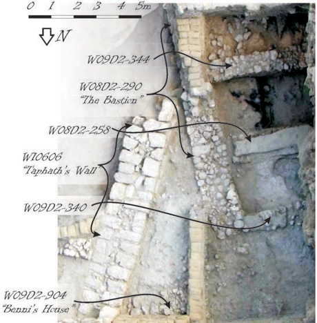
Figure 4 Aerial view of the 2009 excavations in area D2, with major features noted, looking south.
Inside (west of) the “Bastion” wall, a set of three E-W walls separates the space into four rooms. Two basic stratigraphic units were noted in these rooms. The earlier of these (revealed thus far only in the two southern rooms) is a thick burnt destruction layer. Above the ashes (cf. the central room in Figure 4) and burnt mud-brick collapse (cf. the southern room) is a set of surfaces marking the upper layer – basically relating to the same architecture (the gray surfaces in the two northern rooms in Figure 4).
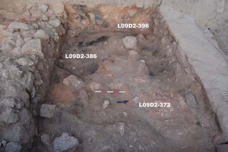
Figure 5 (p09D2-9530) The destruction layer in the central room. Note pottery in articulation at the back.
This presents an interesting stratigraphic conundrum. Outside (east of) the ‘Bastion’ wall -- and indeed in all other excavation areas at Dor -- the only burnt layer is that of the end of the ‘Ir1a’ horizon – phase D2/13. East of the Bastion, that layer was found some 3m lower than the burnt layer excavated this season west of the same wall, and covered with an overburden of five stratigraphic phases (12–8; comprising altogether 10 stages) between it and “Taphath’s Wall” of phase 7. East of (inside) the ‘Bastion’ there is only one set of surfaces between the burnt layers and “Taphat’s Wall” relating to just one architectural phase. (The only place in this row of squares were Ir1b deposits may have been excavated is in the northwestern part of the northernmost square – the so-called 'green deposit' on account of the conspicuous patina on its potsherds; however, its attribution specifically to Ir1b rather to Ir1a will have to be corroborated by further ceramic analysis). One way out is to assume that the two destruction layers are not the same. The artifactual evidence, however, while not yet conclusive (see below), indicates that the destruction indeed dates to Ir1a. If this is indeed the case then either the later Iron Age phases inside the “Bastion” are telescoped -- i.e. while the area east of the wall underwent many upheavals the only change west of it was gradual (and minute) raising of floor levels – or they are truncated – the whole later phase of the Iron Age I is missing west of the “Bastion” wall due to later leveling operations, presumably ones related to the construction of “Taphath’s Palace”.
If the (plausible) attribution of the 'new' destruction, west of the Bastion, indeed dates to Ir1a, the significant difference in elevation of this horizon east and west of the Bastion needs to be accounted for. There are 3 main possibilities: (1) That the Ir1a (early?) accumulations west of the bastion are much (!) deeper than on its east. (2) That west of Bastion (only) Bronze Age remains underlie the early iron Age ones (the "acropolis theory". (3) That west of the bastion bedrock is much higher than on its east. (Any combination of the above is, of course, also possible.)
One remarkable find in the upper (post-destruction) phase was made in the southern room. This room was divided by a set of mud-brick north-south partitions into cubicles of just about 70 x 70 cm. in size. In one of them, above a mud-brick surface, were found two complete small vessels (a juglet and a bottle), a small stone bowl, a horn core, an incised bone, and seven water-polished fist-sized pebbles. This was quickly dubbed ‘the Sikil Shrine’ – though the actual function of this strange assemblage is moot (Figure 6).
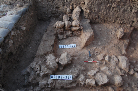
Figure 6 (p09D2-9509) “The Sikil Shrine” – note small bottle at the back.
Within the destruction itself we so far excavated only one half of one room to the floor. Several layers were distinguished within the destruction. The highest was a thick collapse of stone and burnt bricks. Under it (but still well above the floor) were several crushed vessels. Below these was a thick black ash deposit, with burnt and disintegrated beams. Below that was the floor which was marked by nothing other than an abrupt change to unburnt sediment. The floor, again, had several vessels on it. We thus seem to have here evidence for a two-story building which collapsed. Apart from the pottery, this room had a remarkable amount of flint artifacts – both finished (and used) sickle-blades, blanks and debitage. It is possible that sickle blades were being made either on the top or bottom floor.
- -- Table of Content -- |
- -- Top -- |
- -- Continue to Area D5 --