Dor 2006 Preliminary Report
Area D1
Introduction
Operations in D1 were concentrated in two different areas. The majority of the workforce, under John Sloan, excavated units AS-AW/15-17, to delineate the line of the east west street of phases 1 - 2 (Roman), located here last season, and to try to finally understand the nature of the presumed Hellenistic temple / monument (phases 2 - 3), intermittently excavated since 1995. This area will henceforward be referred-to as 'western' (or 'upper') D1. A smaller group, with Rebecca Karberg, was trying to locate the northwards continuation of W26249 ("Big Auntie") of phase 4 in AP-AR/13-16 - and only incidentally dealt with subsequent phases. We will call this area 'D1 East'.
D1 West - Mainly Late Hellenistic - Roman
The purpose of excavating here was to attempt to finally resolve the question of the nature of the 'monument'. In 1995, a molded toichobate (wall-base) was located on what was then the northern edge of area D1 (W16020, Stern et. al. 1998: 35). Since it was found right beneath the surface, and since molded architectural fragments at Dor were then thought to date exclusively to the Roman period, we relegated it to the same period.

Fig. 3
Excavations in 1998 revealed a complex of structures of phase 3 (late Hellenistic) west and southwest of the 'monument' and a set of walls - of a typical 'early' construction technique (ashlar pier) - connects the two structures and abuts the toichobate. Since a molded toichobate is obviously the adornment for the back side of a free-standing monument (temple, tholos, treasury etc.); our 'monument' now appeared to be Hellenistic in date. Even in the (unlikely) event that the connecting walls between the two structures are of phase 2, they are a later addition, indicating the disuse of the 'monument' - at least as a free-standing structure.
Our attention was re-drawn to the 'monument' in 2000. Finding many architectural elements, including a Nike akroterion, reused in early-Roman and Hellenistic walls, we started looking for a dismantled structure that that might have been the origin of these. It was clear that our 'monument' is not the only source of all of these elements since some of the elements were reused in phase 3 walls and hence must be earlier. However, by now we were sure, contrary to our earlier views, that at least some Greek construction styles were evident in the public / elite sector of Hellenistic Dor.
In an effort to define the size and possible nature of the 'monument' we opened a series of excavation units to the north of area D1 on the last week of excavation in 2000 (Hadashot Arkheologiot 119 - In Press). The results were disappointing. The upper strata appear highly disturbed here. Of the western wall of the 'monument' (W16850) only a foundation-course remained, which extended to the northern edge of the square. The rest of the walls quickly dwindled into robber-trenches. The one additional piece to the puzzle was that a Roman cement foundation, apparently of phase 1, clearly cut the 'monument', strengthening the conclusion that it was (at least relatively) early.
In 2005 (Web report) we opened yet-another unit (AV/17) northwards, to try to finally trace the northern edge of the 'monument'. We did indeed find a northwest corner here - cut by a phase 1 kiln - but question-marks multiplied. The width of the western wall was slightly different than the parts excavated in 1995-2000, the foundations appeared differently constructed, and abutting the northern wall of the structure was a street-pavement with a drain - apparently one of the phase 2 Roman streets - whereas Roman remains clearly cut the south edge of the 'monument'.
The task put to John Sloan this season, therefore, was to finish excavating the 'monument', try to date it, and to trace its eastern edge.
It quickly became obvious that the pavement north of the 'monument' is indeed a Roman street, which runs E-W (Figure 4) The pavement was hacked through the center - apparently to rob out the drain under the street. Several feeder-drains leading into the robber trench indicate the function of the ghost feature.
Balk removal, re-cleaning and re-examination of previously- excavated units revealed a detail that was missed in 2000. Just at the northernmost point of W16850 in unit AV/15, was a built corner - though the wall which extended eastwards from it was completely robbed out. This means that we have not one, but two independent structures (henceforward 'Monument A' in the south, with the molded base and 'Monument B' north of it).
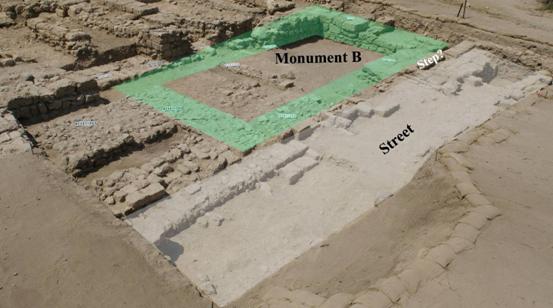
Fig. 4
Each is a small, thick-walled, rectangular building, measuring 6 x 10 m. (Monument A) and 5 x 10 (Monument B). That 'Monument A' is most likely phase 3 was verified this season both by the fact that it sits right on top of phase 4 (it apparently supersedes the 'Persian Palace' - see below), and that there are at least two distinct construction-phases on top of it (Figure 5).
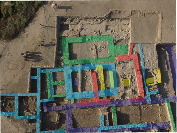
Fig.5
'Monument B' is apparently constructionally-later than 'Monument A'. It could have been built later within phase 3, or it might be phase 2. At any rate its northern wall is flush with the paved phase 2 street, and near its northwest corner is a wide built step from the street onto the line of its [robbed, at this phase] wall (Fig 3) - indicating an entrance into the building (or into a later structure built along the same line). East of 'Monument B' it is abutted by two very thick foundations. If 'Monument B' is an east-facing prostyle structure these (or perhaps only the southern of them) might be the base of a ramp or staircase leading up to it. As it is slightly off-center and slightly off-orientation it is more likely to be a later addition to the structure and not a part of its original plan.
What these 'monuments' are is still moot. They may well be twin-temples - preceding the monumental Roman temenoi F and H (of phase 1). Assuming that they (both or only one of them) date to phase 3, they must somehow be associated with the palatial structures that surround them (at least on the south and west, presumably also on the east).
We further investigated two square stone-lined pits dug east of the 'monuments' in phase 2. That one of them (in AS/15) was a kiln or furnace of some sort was obvious already last year, but few traces of vitrified slag and no wasters were found to give any hint as to its possible function. Extensive sediment sampling by the Weizmann group followed by analytical analysis using both XRF and FTIR showed one distinct anomaly - high concentrations of lead and copper and the presence of heat altered sediments. Highest values were detected inside the installation but also in its near vicinity.
Further lab analysis of the only piece of slag found, suggest that this installation was used for the production of leaded bronze, which is typical for the period.
Investigation of the other square pit in square AT15 revealed no indication that it is a kiln at all, and hence the external similarity between the two installations may be accidental.
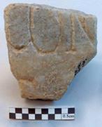 All of these features are disused and covered over when a large structure is built over them. To this structure belong the walls we observed to cut the 'monument' many years ago. Extant walls make for one large square hall of about 8 x 8 m., part of another space west of it, and what must have been an open courtyard to the east - between it and the D4 industrial complex / bathhouse (Web report). Two floors were found just beneath the surface - both in the hallway and the area east of it. Some rather late finds - including a fragment of a Byzantine(?) inscribed marble slab (Figure 6), from under the upper floor raise the suspicion that this surface is later than the (presumably Roman) phase 1. If so, it may have something to do with the entryway into the Crusader tower, which presumably was around here, or perhaps even be modern (a parking lot in front of the Israeli coast-guard outpost?) Last year, a modern bottle-fragment was found under the same surface and presumed to be intrusive.
-- Top --
D1 East - Hellenistic
The main feature excavated over the years in D1 is the so-called 'Persian Palace' - a major public building of the Hellenistic period. By the end of the last campaign of excavations (2000), it became obvious that the structure we had, already extending over 300 m.2 (24 x 13 m.), was merely one wing, abutted onto the southwest corner of a larger structure. In previous seasons we had already traced (and largely removed) the southern wall of this structure in area D2 for some 15m. (W26000 = W17562 in D2). Its extraordinary thickness earned it the nickname 'the BIG mother wall' (and hence the 'Big mother building'). The main objective of excavations in D1 (east) ever since 2004 was to locate the western wall of this building and to see how far north it extended - in order to get an idea of the overall size of the structure - and what it might take to excavate it.
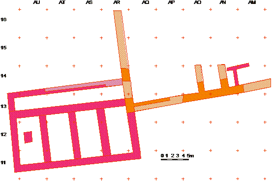
Fig. 7
By the end of the 2005 season the only additional information we had was negative - it was clear that the northwestern extension of 'The Big Mother Building' had suffered heavy disturbance - from stone robbing and from the sinking of the foundations of a large Roman industrial(?) establishment of phase 1 and 2 - which in turn was heavily robbed too. Units AR-AQ/14-16 were almost empty of existing architecture and criss-crossed by late trenching.
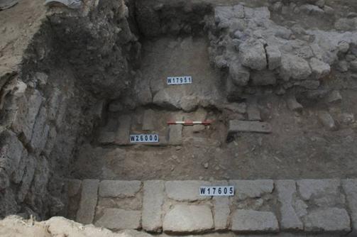
Removal of the last vestiges of these late disturbances revealed yet another robber trench. This time, however, it appears that this is the RT of W26249 (a.k.a. "Big Auntie"). This was suspected by the width and orientation, as well as the deposits in the robber trench and adjoining it - mud brick material very different from the loose sediments encountered in the Roman robber trenches and containing only Persian and Hellenistic pottery . This was corroborated by the end of the season by the finding of an extant section of the wall under the robber-trench (Figure 8). Like the 'Big Mother' wall, this one is made from relatively small ashlars (about 35 x 25 x 15 cm. each) and is three-header thick. Unlike the former - which was constructed in the 'interlocked boxes' pattern this one is constructed in another typical ashlar construction pattern - compartment building - in which ashlar compartments are filled with small fieldstones and mud-mortar. By the end of the season only a small portion of the wall was located, and it is not yet clear how deep its foundations go - and hence if it is likely that further extensions of it will be located under the robber trench or if it is completely robbed-out.
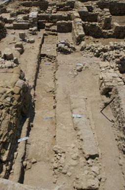
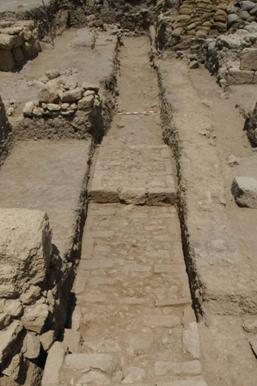
Fig. 8
The robber trench, at any rate, extends to the very edge of the excavated area in AR/16 (Figure 8). This means that the extent of 'the big mother building' is over 18 x 26 m. (nearly 500 m.2). Together with its 'Persian Palace' extension it measures by now some 48 x 27 m.. This is surely one of the biggest palatial structures known in the Levant (Figure 9).
The bad news is that the wall is preserved at foundation-level and little - if any - of the original floor deposits related to the building remain. Although several small fragments of potential phase 4 deposits were identified, these, too are not sealed.
Incidentally, several features of later phases were identified and can fill some gaps in the stratigraphic picture, without changing it much. These include a well-constructed ashlar wall of phase 3, built above-and-alongside the thick phase 4 W26000 ('Big Mother') -(Figure 10). This wall is the direct continuation of W17605 of phase 3 in D2 and may serve to further correlate the stratigraphies of these areas.
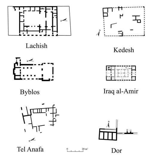
Fig. 9
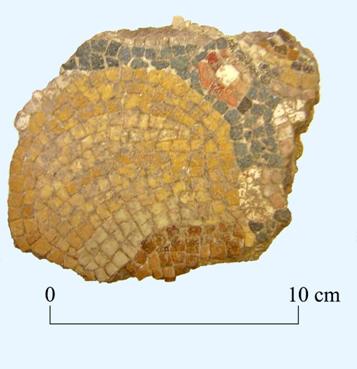
Of the finds from these late features a largish piece of the mask-and-garland mosaic found in this area in 2000 should be mentioned (Figure 11).
Figs. 10, 11
Area Supervisors Reports (PDF files):
- Area D1 East
- Area D1 West
- Full versions (authorized access)
- -- Table of Content -- |
- -- Top -- |
- -- Continue to Area D2 --